Project status
Last Updated: June 16, 2026
The phase 1 of public engagement is complete. A What We Heard Report has been published on this website. Thank you to everyone who participated at the public open house, by submitting a survey, or by sending correspondence. Residents may continue to submit correspondence to the lead planner, throughout the project.
The internal technical review process is ongoing.
January 2026: New "Frequently Asked Questions" have been added.
Project overview and background
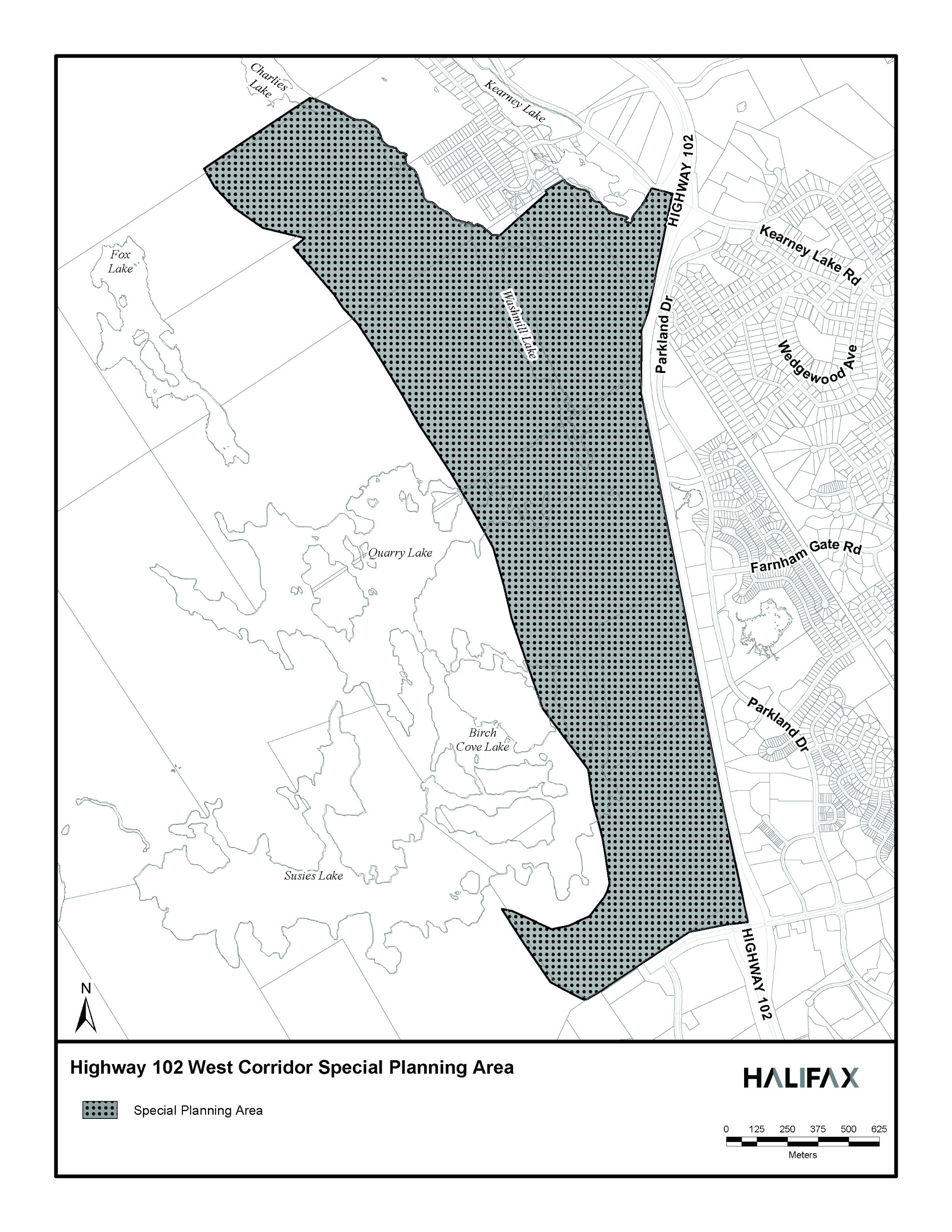
The Highway 102 West Corridor Special Planning Area is approximately 255 hectares (630 acres) of land located west of Highway 102 between Kearney Lake Road and Lacewood Drive in Halifax. The 2006 Regional Municipal Planning Strategy designated these lands as “Urban Settlement” (US) - a potential growth area where sewer and water services may be extended to allow the development of a new community within the plan’s intended timeframe.
In January 2022, Regional Council directed staff to advance background studies needed to consider urban development of four potential Future Serviced Communities. The Highway 102 West Corridor Lands were included in that study. More information on the Future Serviced Communities (FSC) Study and the completed reports for this Special Planning Area can be found under the Documents panel to the right.
On May 16, 2025, the lands were designated a Special Planning Area under the Housing in the Halifax Regional Municipality Act by the provincial Minister of Growth and Development therefore initiating comprehensive neighbourhood planning for the Highway 102 West Corridor Special Planning Area.
A comprehensive neighbourhood planning process considers all aspects of planning a new neighbourhood. Strategic investments in infrastructure, parks and facilities will be identified to support the new community. The outcome is new municipal policies and regulations to guide and support new development in the area informed by HRM priority plans, public consultation, collaboration with internal and external review agencies, proposals from landowners, and supporting studies.
The recently completed Future Serviced Communities Studies provide the required background technical information on:
- extending water and wastewater services;
- upgrading transportation infrastructure; and
- assessing the environmental and cultural impacts of developing these lands.
With these assessments complete, comprehensive planning can begin. Additional technical assessment of infrastructure and mobility needs will be undertaken as part of the planning process. While there are environmental and infrastructure matters to address, preliminary modeling suggests that the lands contain sizeable areas suitable for urban development that could support population growth in the medium to long term.
What is the proposed planning process?
The comprehensive planning process will address what is needed for a new complete community through a neighbourhood plan for the entire area. This will include public infrastructure, streets, parks, pathways, housing mix, land uses and transit service. Coordination with review agencies will enable consideration of services such as schools and infrastructure upgrades such as 100 series highways. Planning policies and regulations will be drafted to guide development.
How can I participate in the process and provide feedback?
Public feedback is welcomed and considered throughout the planning process. There will be two phases of engagement. Phase 1 took place beginning in November 2025. Residents participated by:
- visit this webpage for information;
- sending questions and feedback to the planner leading this file (see “Who’s listening” above);
- attending a public open house on Nov. 19; or
- fill out an online survey on this webpage.
Phase 2 will take place when draft planning policies are ready to share for public comment.


