Project update: Revised project schedule
The original target to deliver a final Functional Plan (30% Design) was winter of 2026. The project schedule has been adjusted as the Greenway Extension and Local Street Bikeway along Roxton Road and Robie Street will be included as part of a Council-requested report for lower cost alternatives in the All Ages and Abilities cycling network. Part 1 of the AAA alternatives report was presented to Regional Council in January 2026, and Part 2 is targeting Regional Council in fall 2026. By aligning our timeline with this report, we will be able to proceed with an option that is supported by Council before completing work on the 30% design phase.
Exploring an alternate route for the proposed Halifax Urban Greenway Extension
In October 2025, the Halifax Regional Municipality asked for public feedback on the proposed Halifax Urban Greenway Extension and Active Transportation Connections to Point Pleasant Park. Thank you to everyone who participated in our initial engagement activities.
Based on that input and according to Regional Council’s request for lower cost alternatives to the All Ages and Abilities (AAA) bicycle network, we are exploring a new alternative for this project.
A Local Street Bikeway is being considered as an alternative to the Greenway option presented in October. The Local Street Bikeway would be located along Roxton Road and the southernmost block of Robie Street (See Figure 1 below).
You can view more details about the Greenway and the new alternate route here.
We are asking for your feedback on both route options. Please scroll down to participate in our new online survey.
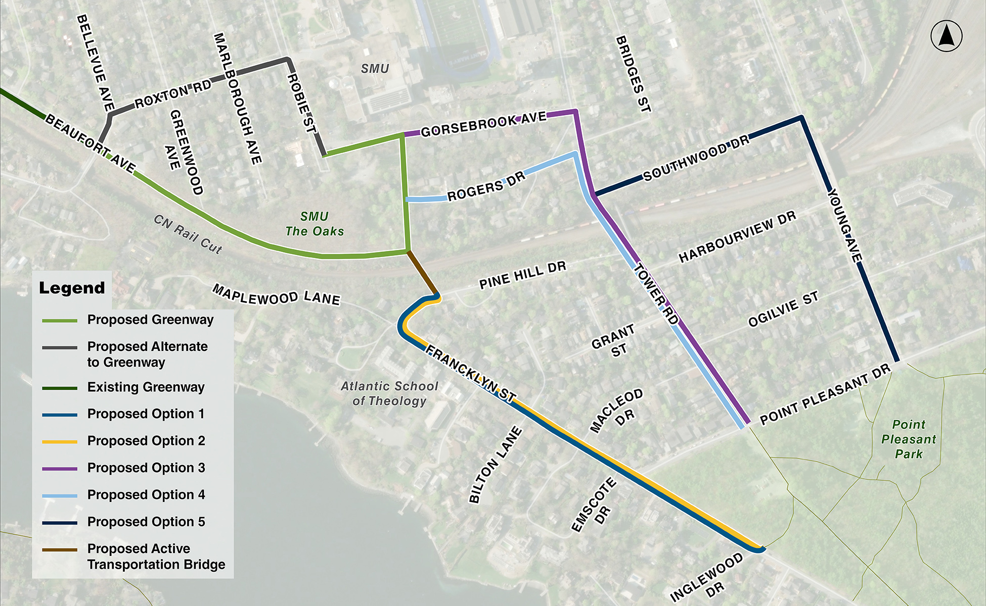
Figure 1 Project area showing the greenway extension with new alternative and options for an active transportation route to Point Pleasant Park
About this project
The Halifax Urban Greenway is an off-road, multi-use pathway accessible for users of all ages and abilities including people walking, cycling and rolling, providing an important active transportation and recreational corridor. The greenway currently extends from South Street and Beaufort Avenue to the intersection of Bellevue Avenue and Beaufort Avenue.
Halifax Regional Municipality (the municipality) is working to fill a gap in the active transportation network. Right now, the Halifax Urban Greenway ends at Beaufort Avenue and Bellevue Avenue. This project intends to extend the greenway through Saint Mary’s University (SMU) campus. In addition to the greenway extension, we are also looking at options to create an active transportation connection from the university to Point Pleasant Park.
The Halifax Urban Greenway is part of the vision set out in the municipality's Integrated Mobility Plan and Making Connections: 2014-19 Halifax Active Transportation Priorities Plan.
The greenway extension and Point Pleasant Park active transportation connection would improve daily travel for residents, students and visitors – whether walking, rolling, or cycling. By connecting key destinations within the peninsula’s south end, the project would enhance access to recreation, facilities and nature.
Project scope of work
This project scope includes the developing a functional plan for two active transportation facilities:
1) A greenway from Bellevue Avenue to SMU (The Oaks):
We are working with SMU to develop the alignment and designs for the greenway portion of the project. The greenway will consist of a 3.0m multi-use pathway from the end of the existing greenway through the campus’ Oaks Property. The pathway will connect to the SMU campus as well as adjacent streets, such as Robie Street and Rogers Drive.
2) An active transportation connection from SMU to Point Pleasant Park:
We are exploring five route options to connect from the end of the proposed greenway to Point Pleasant Park. These options are colour-coded on the map above. The options provide different active transportation facility types and routes to connect to the park. Community input will help us identify a preferred option.
This project will require Regional Council approval and budget allocation before moving to detailed design or construction.


