Get involved and stay informed
Help us shape the future of our suburban communities
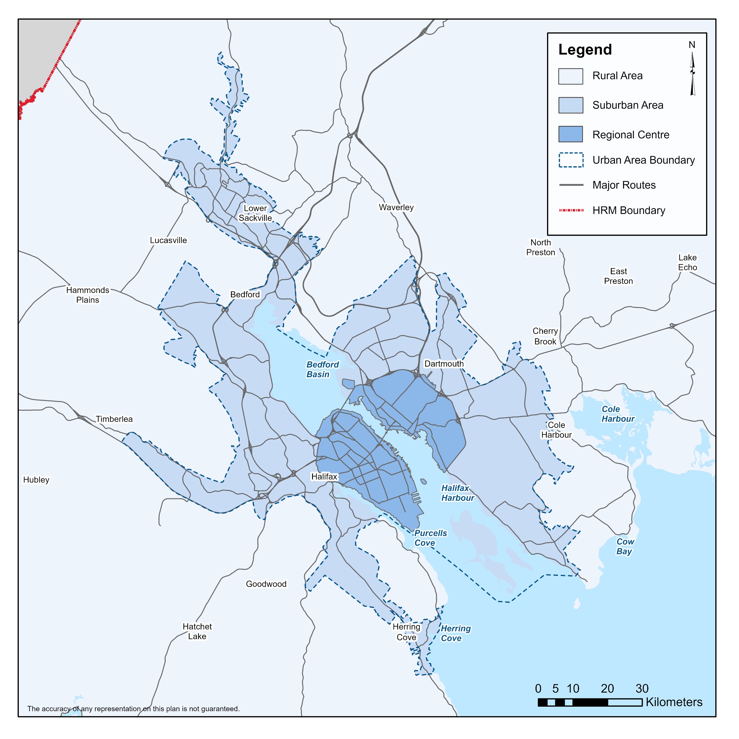
Halifax Regional Council started the suburban planning process to develop a new vision for land use in our suburban communities. The Suburban Area is generally located outside of the Regional Centre (Peninsula Halifax and Dartmouth within the Circumferential Highway) where there is access to main transit, piped water and piped wastewater systems.
To check if a property is in the Suburban Plan Study Area click here.
The Suburban Plan will refresh, improve, and create new land use policies and regulations that better reflect the needs of our suburban communities. It will consider the unique histories, characteristics and aspirations of communities under an updated planning framework. It will also consider recent and anticipated population growth, and the needs for improved infrastructure and services.
As part of this process, we’re asking residents to share what they value about their communities, what makes them unique, how they connect to the wider region and how they’d like to see them grow and change in the future.
This website is the place where you can access content, materials and supporting research for the Suburban Plan. You can also find out about upcoming in-person engagement events as well as opportunities to provide feedback online.
Sign up for our newsletter mailing list to stay tuned on upcoming in person engagement opportunities. As well, there will be more surveys and opportunities for engagement announced through our newsletter.
Have your say
Suburban Area Interactive Map
Intro Survey
Main Street Interactive Map
Learn More
Newsletters
Community Map
For best viewing experience of the Suburban Plan Engagement Map click here.
Presentation and Videos
Intro to Suburban Plan Video
Kick-Off Open House Presentation
Fact Sheets and Info Boards
Fact Sheets
-
 What is the Suburban Plan Fact SheetPDF (116.87 KB)
 -
Planning 101 Fact SheetPDF (124.61 KB)
-
Zoning 101 Fact SheetPDF (94.83 KB)
-
Land Use and Design Fact SheetPDF (41.60 KB)
-
Complete Communities Fact SheetPDF (257.06 KB)
-
Housing Fact SheetPDF (77.46 KB)
-
Mobility Fact SheetPDF (188.28 KB)
-
Environment and Sustainability Fact SheetPDF (225.13 KB)
-
Culture and Heritage Fact SheetPDF (181.43 KB)
-
Economy Fact SheetPDF (333.61 KB)
-
Ongoing and Related Work Fact SheetPDF (518.72 KB)
-
ANSCAP and the Suburban Plan Fact SheetPDF (118.62 KB)
-
Priority and Strategic Plans Fact SheetPDF (1.39 MB)
-
Ongoing Community Planning Processes Fact SheetPDF (167.36 KB)
-
Suburban Plan Activity SheetPDF (368.96 KB)
Open House Information Boards
-
What is the Suburban Plan BoardPDF (2.51 MB)
-
Land Use and Design BoardPDF (7.63 MB)
-
Complete Communities BoardPDF (10.05 MB)
-
Housing BoardPDF (86.54 KB)
-
Mobility BoardPDF (2.14 MB)
-
Environment and Sustainability BoardPDF (5.06 MB)
-
Culture and Heritage BoardPDF (3.43 MB)
-
Economy BoardPDF (2.67 MB)
Community Profiles
-
Suburban Area Community ProfilePDF (2.88 MB)
-
Armdale Community ProfilePDF (1.83 MB)
-
Beaver Bank Community ProfilePDF (594.43 KB)
-
Bedford Community ProfilePDF (779.96 KB)
-
Beechville Community ProfilePDF (666.89 KB)
-
Clayton Park Community ProfilePDF (748.36 KB)
-
Cole Harbour Community ProfilePDF (777.18 KB)
-
Dartmouth Community ProfilePDF (2.28 MB)
-
Eastern Passage and Shearwater Community ProfilePDF (1,013.79 KB)
-
Fairview Community ProfilePDF (704.95 KB)
-
Herring Cove Community ProfilePDF (1.06 MB)
-
Lower Sackville Community ProfilePDF (978.19 KB)
-
Middle Sackville Community ProfilePDF (994.37 KB)
-
Spryfield Community ProfilePDF (1.40 MB)
-
Timberlea and Lakeside Community ProfilePDF (873.58 KB)
-
Westphal and Lake Loon Community ProfilePDF (644.73 KB)
Current Projects Informing the Suburban Plan:
Public survey now closed
We were surveying residents, visitors, and people working in HRM to gain a better understanding of how and where people shop and access services.
The feedback is valuable in helping to understand the amount, type and location of new retail and service commercial space needed to serve HRM’s urban and suburban communities.
About the project
Having areas where people can shop and conveniently access services is an important part of creating complete urban and suburban communities. To support economic development and make sure our planning documents reflect the needs of businesses and communities, we need to understand:
- What different types of commercial and retail spaces exist today, and what is missing?
- Where are businesses doing well and where are they struggling? What factors may be influencing this?
- What kinds of retail spaces are businesses looking for?
- How do land use regulations impact businesses and commercial spaces?
This project will involve engagement to better understand the needs of business owners, those working in commercial development, and residents.
Main streets are often the heart of a suburban community. They are where residents go for their groceries, entertainment, retail, services, and community gatherings. Given the current growth pressures in the urban core, we would like to better understand:
- How each major main street in the Suburban Plan Area currently functions;
- What aspects of each main street should be preserved or built upon; and
- What type of change and development residents, business owners, and property owners in each area would like to see in the future.
We are now launching main street visioning workshops for 10 suburban main streets across the Suburban Plan Area. These workshops will provide opportunities to share your ideas on building and public space design, the types of stores and services you’d like to see, accessibility improvements and more. Community members will collaborate to create a unique vision and guiding principles for their local main street.
This workshop is open and free to anyone with an interest in suburban main streets, however we strongly encourage those who work, live, own property or spend a lot of time on one of the listed main streets, to attend. Registration is encouraged, as space is limited. To register for one of the main streets, click on the link associated with an event below.
Community plans consider the history and culture of communities when developing the vision for areas. The consultant for this project will start researching the histories of each official community, examining traditional Mi’kmaq use, the historical and/or cultural significance of each community, contributions of diverse backgrounds, and identify potential important public views, landmark buildings, and Heritage Conservation Districts.
This project will include engagement with museums and culture and heritage groups. The results of this research will be a starting point, and the stories of each community will continue to be built through further engagement and research. Stay tuned for updates on this project.


